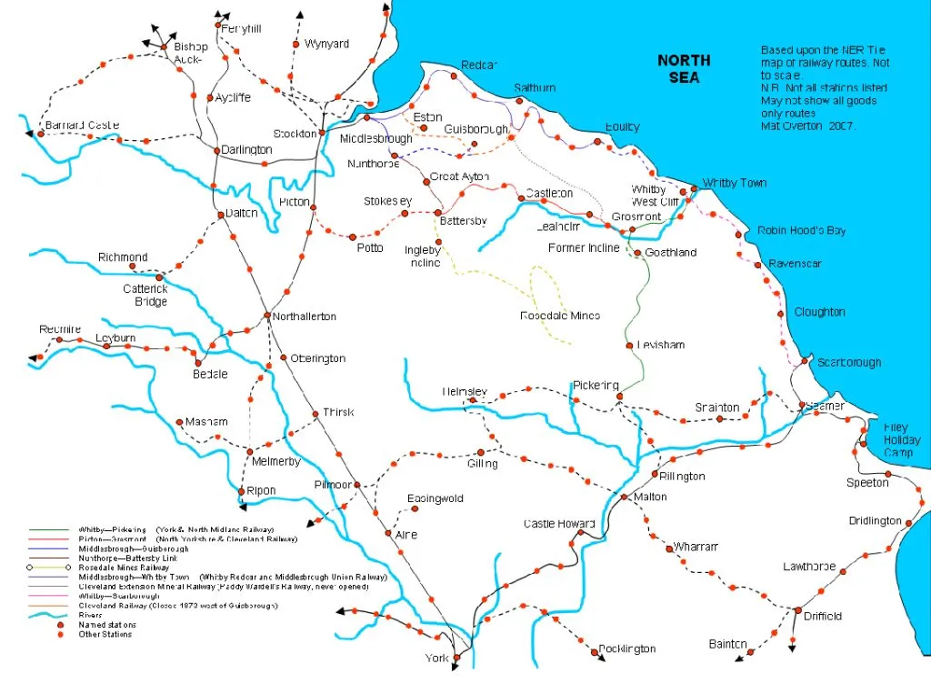
This was the final walk along the route of the Middlesbrough to Scarborough railway, taking in the remaining seven stations. You can catch up on the previous four journeys here: Part One, Part Two, Part Three, Part Four.
My previous walk had taken me as far as the site of Robin Hood’s Bay railway station. The final journey took in Fyling Hall, Ravenscar, Staintondale, Hayburn Wyke, Cloughton, Scalby and Scarborough, the 19th and last of the forgotten stations.
Robin Hood’s Bay
My previous visit to Robin Hood’s Bay was curtailed by a thunderstorm, and I didn’t get further than the railway station. But this time I had time to visit the village itself, the jewel in the crown of North Yorkshire fishing villages. King’s Beck flows through the village, and over cobbles before entering the North Sea across the beach.


Fyling Hall railway station
I picked up the route of the Cinder Track again, and headed towards Fyling Hall, probably the remotest station on the railway, an hour’s walk from Robin Hood’s Bay. The vegetation is thick here, and the overbridges resemble Victorian gothic follies.


It’s hard to imagine why the Scarborough and Whitby Railway Company built a station in such a sparsely populated area, with little prospect of goods traffic either. Fyling Hall railway station opened in 1885, closed in 1915 during WW1 as an economy measure, reopened in 1920, became an unstaffed halt in 1958, then closed along with the rest of the line in 1965. A degraded platform is all that remains of the station. Immediately south of the station, an underbridge has been removed, and a sign points to Boggle Hole. It’s a real place.


Ravenscar railway station
Almost as soon as I left Fyling Hall station I started the climb towards Ravenscar, the highest station on the line, on a cliff top190 metres above sea level. The track bed curves to the east and reveals a stunning view back to Robin Hood’s Bay


The climb required gradients of up to 1 in 37, a difficult ask for an adhesion railway at the best of times, but the line here was subject to the microclimate of the North Yorkshire coast. Sea fret would cause wheel slippages, bringing trains to a halt, and engine drivers would often have to reverse their trains several times before making the summit. Ravenscar itself is a ghost resort. At the turn of the 20th century, unscrupulous property developers sold plots of land for a beach resort that never existed. The North Sea is at the foot of a sheer cliff, and there is no beach, just a rocky ledge. Only one building was built at Ravenscar, at Station Square, but Station Square was never completed either. Only the platforms of the railway station are extant, just about visible in the undergrowth.


An engineering challenge
There was hardly any level land along the route of the Middlesbrough to Scarborough railway. The engineers had to build viaducts, cuttings and embankments almost everywhere they went. On the slow descent from Ravenscar to the edge of Scarborough, the line crossed several deep ravines, requiring huge embankments over each of them. These embankments would have been bare earth when constructed 139 years ago, but they are covered in mature woodland now. In times of heavy rain, the streams can be heard gurgling through the culverts under the embankment but, because of the undergrowth, they cannot be seen.
Stainton Dale railway station
Stainton Dale was the next station south of Ravenscar. Like so many rural stations in the UK, it was some distance from the village it served. The station, another beautiful stone building, was opened in 1885 and closed in 1965. The platform clock can still be seen.


Stainton Dale frequently won prizes for the best kept station on the line. This tree house that has been built on the surviving platform could win a prize itself.

A bucolic landscape
Heading south, I headed into a landscape that isn’t typical of the North York Moors national park, dotted with a series of woods, meres and cow pastures that John Constable could have painted. The nearest ‘A’ road is a long way away, and all that you can hear is birdsong.


I approached the site of Hayburn Wyke railway station, another station that could never be justified economically, but those ambitious Victorians built it anyway. It opened in 1885, was temporarily closed due to WW1, from 1917 to 1921, and became unstaffed in 1953. The station building was converted to holiday accommodation then, but the station itself remained open until the line closed in 1965.


A footpath leads down through Hayburn Wyke nature reserve to the beach, where a waterfall divides into two before spilling into the sea. Beware though, it’s a challenging walk.


Cloughton railway station
Continuing down to the next railway station, Cloughton, the Cinder Track has become severely rutted due to recent extreme rainfall. Here, the track bed has almost been destroyed.


The station building at Cloughton still survives, a handsome stone building that has been extended to the north. Cloughton opened and closed with the railway line, being open from 1885 to 1965. The goods shed has been converted into a house.


It’s a very muddy hour’s walk from Cloughton to the next station, Scalby, but under the shade of the trees you don’t notice it.
Scalby railway station
Scalby station opened in 1885, but it was the first station on the Whitby to Scarborough section to close, in 1953, although trains occasionally called there until the line closed. In 1974, the route of the line through Scalby was senselessly obliterated by housing development, and there is no trace of the railway station. To add insult to injury, stone from the station building was incorporated into some of the houses that replaced it. On a hot day, you can take a ten minute detour to the Nag’s Head pub in the village centre for a pint of Tetley’s Imperial. And I did.


Scalby Beck
Immediately south of Scalby station the track bed crosses the gorge of Scalby Beck on a spectacular brick viaduct. The river Derwent once flowed to the North Sea here, but it was blocked by glacial mud at the end of the last ice age, and now flows south instead of east, leaving the much smaller Scalby Beck to occupy the gorge. 220 years ago, engineers created the 5km Sea Cut, which reopened the river route, but only in times of heavy rain. Downstream flooding of farmland is prevented by diverting surplus water through the cut. Any water that remains in the Derwent takes a 240 km journey south to the sea at Spurn Head, via the rivers Ouse and Humber.


Approaching Scarborough
After crossing Scalby Beck I reached the outskirts of Scarborough. The overbridges become wider here as the track bed approaches Gallows Field, the site of Gallows Close goods yard, where the line fanned out into numerous sidings.


The goods yard was busy in its heyday. In addition to handling freight in its own right, it acted as an overspill facility for Scarborough railway station. The yard included a turntable to enable locomotives to reverse. It’s still there, buried beneath the Gallows Field. Gallows Close goods yard outlasted the rest of the railway by 20 years, finally closing in 1985. The line continued through the suburbs until more sidings were reached, at Northstead, just south of Wykeham Street. A Sainsbury’s supermarket has been built over the site, and there is nothing left of the railway sidings. The size of the railway footprint is indicated by the width of the road bridge here. The running line was on the extreme left of the first photograph.


The final forgotten station
I was approaching the 19th, and final, forgotten station on the Middlesbrough to Scarborough railway, but there was a problem. It doesn’t exist, and never did. The railway had been planned since 1848, but wasn’t built for another 37 years. The railway company had intended to build a new station to the west of the existing station. In the intervening period, Scarborough had undergone a building boom, and the land wasn’t available. The builders of the line came to an arrangement to share the existing railway station on a temporary basis, but the temporary arrangement became permanent.
Falsgrave Tunnel
To make matters worse, the line engineers had to build a 220 metre long cut-and-cover tunnel under Falsgrave Road, which connected with the existing York to Scarborough line behind Falsgrave signal box, but facing the wrong way. Trains then had to reverse into Scarborough station. Trains travelling in the other direction had to repeat the process, an activity which hampered the railway throughout its existence, adding unnecessary minutes to every journey.


Scarborough railway station
The station was built by the York and Midland railway in 1845. It was extended to the east as holiday traffic boomed. These extensions still exist, but are no longer rail served.


The end of the line?
Our journey ends here, but it needn’t. In a future article, I’ll talk about a radical plan to reopen the entire 93 km route of the Middlesbrough to Scarborough railway, converting most of the forgotten stations into modern transport hubs, providing efficient transport links to some of the UK’s most deprived coastal towns, and reviving the finest scenic railway line in England.

CLICK HERE TO DONATE TO OUR CROWDFUNDER
HELP US BECOME STRONGER SO THAT WE CAN CONTINUE TO DELIVER POWERFUL CITIZEN JOURNALISM!