




Oh, Doctor Beeching!
The UK is dotted with thousands of forgotten and abandoned railway stations, some in our inner cities, but most in rural locations. The North East of England and North Yorkshire is no exception, and took one of the hardest hits. Many of the stations were so remote and isolated that you wonder why anyone built a station in the first place. A lot of them were victims of the so-called ‘Beeching Axe’ following the Reshaping of British Railways report by Dr Beeching in 1963. But this line was typical of most rural railways in the UK. Most of the stations north of Whitby closed in 1960, before the axe. Most of the stations south of Whitby closed in 1965, after the Beeching Axe, and also after a Labour government was elected. The new government didn’t stop the axe and the majority of Beeching closures occurred during their administration.
A slow decline
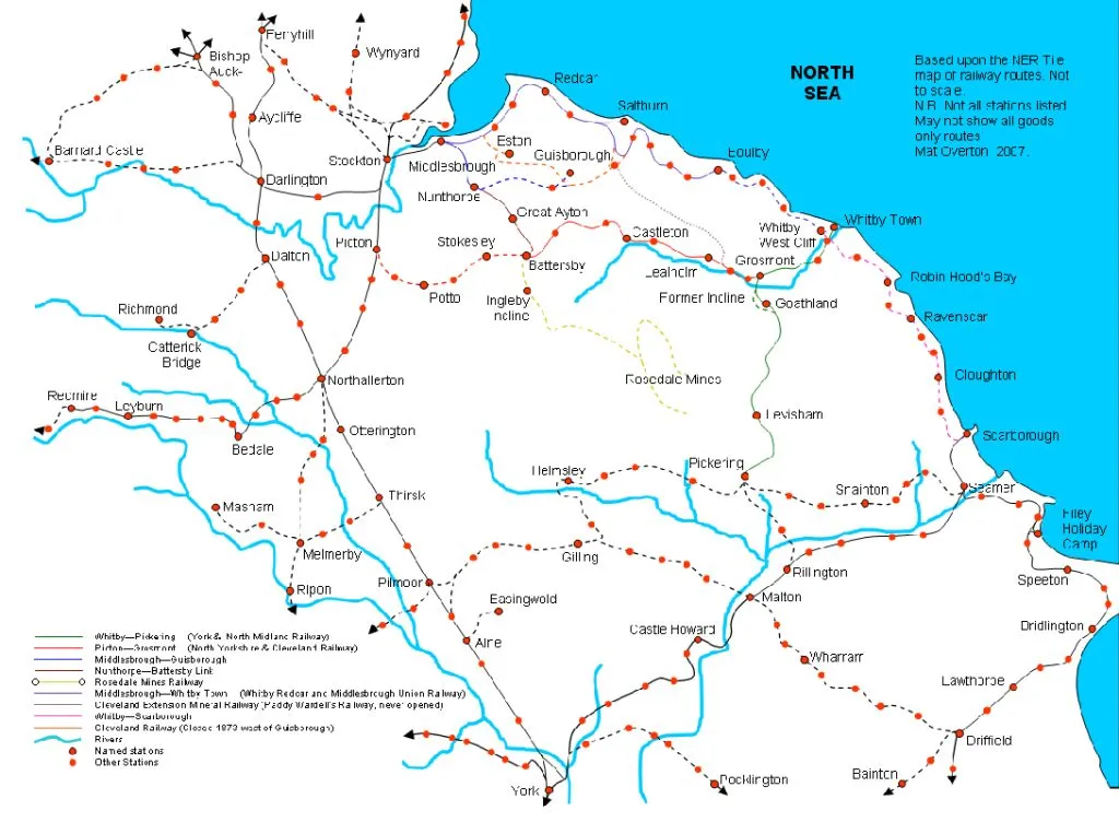
History of the route
The route consisted of a combination of three lines built by two railway companies. At Saltburn, the first part of the route, the Whitby, Redcar and Middlesbrough Union Railway was constructed in 1871, branching off the North Eastern Railway at Saltburn West Junction, just ahead of the terminus station there, and reaching as far as Loftus. 12 years later, the line was extended from Loftus to Whitby. Separately, the Scarborough and Whitby Railway was completed in 1885. Middlesbrough and Scarborough were now connected via this coastal route, but a through passenger service between the towns didn’t commence until 1933.
Walking the route
I walked part of the route on 10 May 2024, visiting the sites of the three northernmost abandoned stations at North Skelton, Brotton and Skinningrove. I intend to visit all 19 sites over the next few months. Here is a description of this part of the route, including the history, and a description of what remains today.
North Skelton railway station
Southbound trains started from Saltburn, which is a terminus, so trains ran to Saltburn West junction, then reversed on to the line towards Scarborough, almost immediately heading across one of several spectacular viaducts on this route, this one being Saltburn Viaduct over Skelton Beck before arriving at North Skelton. This is the viaduct pictured in January, before being obscured by spring foliage.

The walk from Saltburn to North Skelton railway station is circuitous, taking me inland along the Cleveland Way, crossing Skelton Beck immediately beneath the viaduct, then skirting the outskirts of Skelton-in-Cleveland to where Wandhills Avenue crosses the railway line via a road overbridge. The station was about 100 metres down a public footpath, an immediate right turn before crossing the bridge. But the goods yard was down a laneway on the other side of the bridge, and I visited that first.
Lost forever
Although this part of the route has remained a busy freight line since its opening in 1871, the passenger station here only operated from 1902 until 1951. I searched for the site of the goods yard, which is now occupied by Cleveland Auto Recyclers. I encountered Jim Wilkinson, the proprietor of this company, who revealed that the stationmaster’s house, the last remaining artefact of North Skelton railway station, had been destroyed in an arson attack in April 2017. Jim, who is extremely knowledgeable about the old station, actually took a photo of the fire. It’s shown below.

I returned back to the bridge, crossed over and headed towards the site of the stationmaster’s house. Only the foundations remain now.

Heading towards Brotton
Typical of many rural railway stations, North Skelton railway station was a considerable distance from the village itself. A 600 metre walk, taking in two steep ravines. This is hilly country. I took this walk, reached Vaughan Street in North Skelton village and turned left towards the next station, Brotton. I immediately encountered two rail overbridges. The first of these is disused. It carried the line from Saltburn to Guisborough. Immediately after this I crossed under our line.

Brotton railway station
I continued along Vaughan Street for about another 2 km, crossed beneath our line again as it loops back over to the north, then turned left into the site of Brotton railway station. The station building is extant. It has recently been re-roofed, but it’s now a Kwik-Fit outlet. The modern extension to the building is hideous and unforgivable. We really should take more care of our heritage than this. The two platforms are extant also, but the site isn’t open to the public. You can see a photo taken just after the station closed in 1960 here, and an exterior shot I took on 10 May below.

Huntcliff and Warsett Hill
After Brotton, our next station is Skinningrove, a mere 2.5 km away. But the mass of Warsett Hill is in our way. The solution for the railway builders would have been to tunnel through the hill, but a tunnel of this length would have been prohibitively expensive to build. So the engineers created a huge loop northwards towards Huntcliff, skirting the summit of Warsett Hill along the cliff top, then curving to the south to reach Skinningrove. This at least tripled the length of the route and created a maintenance headache which still persists to this day. And locomotives still had to ascend and descend Huntcliff, 110 metres above sea level. On the plus side, it’s one of the most dramatic stretches of railway in the UK, little known about because it’s only a freight railway these days. However, to get here on foot from Brotton requires a diversion almost as far as Saltburn, because much of Warsett Hill is private farmland. It was a gruelling uphill slog on an unseasonably oppressive and humid 10 May. The ‘Circle’ Sculpture by Richard Farrington, marks the summit of the line. It’s known locally as the Charm Bracelet, and on breezy days the charms turn into wind chimes. But there was no wind on my visit.

The impact of climate change
I chatted with a Network Rail contractor, whose company is monitoring the movement of the Huntcliff, just metres away from the railway line. They’ve just undertaken a 3-D aerial survey of the cliff, and over the past two weeks they’ve been installing sensors which will detect the smallest earth movements and report them back in real time. This section of track was always expensive to maintain, and more frequent climate change related events are adding to the problem.

Huntcliff ironstone mine
The railway line and the Cleveland Way diverge here. The railway line heads south, while the path keeps southeast along the cliff top. The Guibal fanhouse, the last remnant of the Huncliffe Ironstone mine, which closed in 1906, can be seen. Ironstone from the mine was fed to Skinningrove ironworks, about 500 metres away, by means of an aerial ropeway. There is no trace of this today.

Skinningrove railway station
As we descend from Huntcliffe we arrive at Skinningrove ironworks. The footpath skirts the north, but the railway heads south of the works, and freight sidings branch off to serve the ironworks. These sidings are still active, bringing in a daily train of steel blooms from Scunthorpe. Skinningrove Jetty and the majestic sweep of Cattersty Sands can be seen below. The jetty was served by a gravity-worked railway incline directly from the works 70 metres above, and exported pig iron to Scotland.


Slag from the blast furnaces was dumped over the sea cliff, creating an artificial extension. Things were done differently back then. The Cleveland Way footpath here is made entirely of slag, and makes a satisfying crunch under your feet.
I ascended the artificial cliff, where the longest rail sidings in Skinningrove Works can be found, terminating only metres from the edge of the cliff.
Skinningrove ironworks is a shadow of its former self, but it still makes a niche product, track shoes for the famous Caterpillar earth-movers, which are exported all over the world.
Skinningrove railway station, also known as Carlin How, the name of the nearest village, was situated just south east of the ironworks. It was open to passengers from 1875 to 1952.
However the railway that we have been following has been in constant use by freight traffic since the line opened in the 19th century. South of here the line was closed completely in 1964. But soon afterwards, large quantities of potash were discovered beneath the North York Moors at Boulby, and a 6.4 km section of the former line was reopened from here in 1974 to connect to the new mine. Several bridges had been demolished and had to be replaced. The first of these is shown here. It was immediately north of the former railway station.
The demon drink
A search for artefacts of the former railway station proved fruitless. Dehydrated after a long day in the sun, I stumbled across the Bullet pub in Carlin how, also known as the Speakeasy, for a pint of beer. As luck would have it, a two-hour storytelling singalong was about to commence. Three pints of Caffrey’s later, I belted out the chorus to ‘The Wild Rover’ with the rest of the crew. The day’s expedition had come to an unexpected but satisfactory conclusion.



